
미리보기 크기: 450 × 600 픽셀 다른 解像度 : 180 × 240 픽셀 | 360 × 480 픽셀 | 576 × 768 픽셀 | 768 × 1,024 픽셀 | 1,536 × 2,048 픽셀 | 4,095 × 5,460 픽셀
原本 파일 (4,095 × 5,460 픽셀, 파일 크기: 5.93 MB, MIME
Summary
| Description |
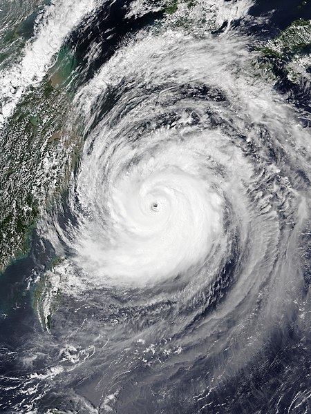
English: Typhoon Maysak at peak intensity near Okinawa on September 1, 2020. |
| Date | |
| Source | EOSDIS Worldview |
| Author | NOAA-20 satellite for the VIIRS imagery |
| Camera location | | View this and other nearby images on: OpenStreetMap |
|---|
Licensing
| This file is in the public domain in the United States because it was solely created by NASA. NASA copyright policy states that "NASA material is not protected by copyright unless noted". (See Template:PD-USGov, NASA copyright policy page or JPL Image Use Policy.) | ||
 |
Warnings:
|
파일 歷史
날짜/
| 날짜/時間 | 섬네일 | 크기 | 使用者 | 說明 | |
|---|---|---|---|---|---|
| 現在 | 2020年9月1日(火)18時18分 | | 4,095 × 5,460 (5.93 MB) | wikimediacommons>Meow | Uploaded a work by NOAA-20 satellite for the VIIRS imagery from [https://worldview.earthdata.nasa.gov/?v=116.0116467637429,20.14549617216907,135.92766238874287,32.85226398310067&l=Reference_Labels,Reference_Features,Coastlines,OrbitTracks_NOAA-20_Ascending(hidden),VIIRS_NOAA20_CorrectedReflectance_TrueColor EOSDIS Worldview] with UploadWizard |
이 파일을 使用하는 文書
다음