
SVG 파일의 PNG 形式 의 미리보기 크기: 250 × 115 픽셀. 다른 解像度 : 320 × 147 픽셀 | 640 × 294 픽셀 | 1,024 × 471 픽셀 | 1,280 × 589 픽셀 | 2,560 × 1,178 픽셀
原本 파일 (SVG 파일,
Summary
| Description |
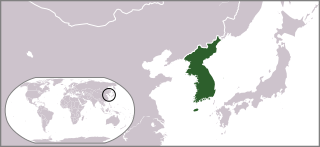
English: Locator map of Korea. |
| Date | |
| Source | Own work |
| Author | Ksiom |
| Other versions |
 |
| SVG development | This locator map was created with Adobe Illustrator. |
Licensing
| I, the copyright holder of this work, release this work into the public domain. This applies worldwide. In some countries this may not be legally possible; if so: I grant anyone the right to use this work for any purpose, without any conditions, unless such conditions are required by law. |
파일 歷史
날짜/
| 날짜/時間 | 섬네일 | 크기 | 使用者 | 說明 | |
|---|---|---|---|---|---|
| 現在 | 2009年7月11日(土)02時38分 | | 250 × 115 (1.18 MB) | wikimediacommons>Ksiom | == Summary == {{Information |Description={{en|1=Locator map of South Korea.}} |Source=Own work by uploader |Author=Ksiom |Date=2009-07-11 |Permission= |other_versions=file:Locationmap Korea.png }} <!--{{ImageUpload|full}}--> == [[Com |
이 파일을 使用하는 文書
다음